How Public Health Experts Use GIS to Fight Disease and Save Lives
Flu season is here again, with all its aches, pains, and fevers. But scientists have a powerful tool to fight back.
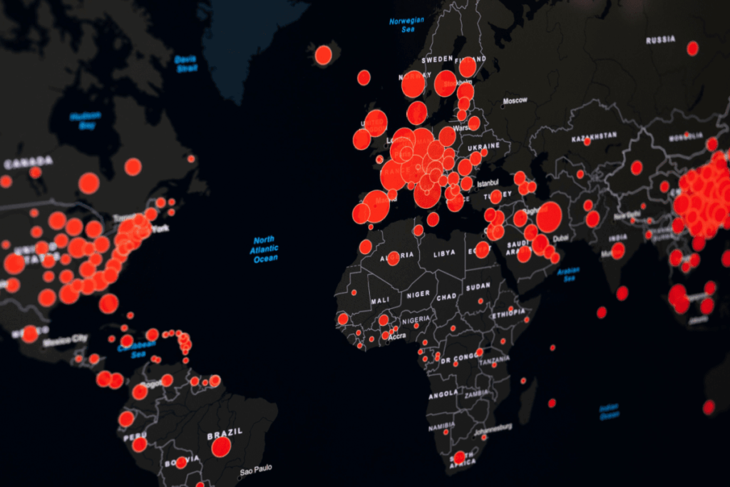
The GPS technology used to plot your rush-hour route home? It also powers GIS (Geosciences Information System) tools that help public health officials pinpoint infectious disease outbreaks, limit their spread, and spot gaps in healthcare access. Whether it’s flu, COVID-19, or emerging diseases, GIS technology helps responders provide timelier and more effective care.
Let’s take a closer look at how public health officials use GIS technology to keep populations healthy.
What Is GIS in Public Health?
GIS tools help public health officials collect and analyze data to make informed decisions about health threats. These tools turn location data into visual maps that show:
Where diseases are spreading
Who might be at risk
Where healthcare resources are needed most
Let’s dig deeper into these three key ways public health professionals use GIS.
#1. Hotspot Mapping: Locating Disease Outbreaks
What’s a hotspot? In public health, it’s a geographic area where many cases of an infectious disease are concentrated. Hotspot mapping helps health officials use geographical and other data to identify these areas. Armed with this information, they can target their efforts and resources, whether they’re dealing with the flu or another disease.
Public health officials collect data from sources like:
Health departments
Hospitals
Electronic health records
Health information exchanges
These officials then anonymize the data to protect patient privacy and convert address details into map coordinates (a process called geocoding). GIS tools and spatial analysis software use special algorithms to quickly analyze massive quantities of location data.
Public health departments put this technology to work during the COVID-19 pandemic. For example, a specialized GIS-based mapping tool gave St. Louis, Missouri, public health officials a street-level picture of cases based on positive test result data. This helped them identify hotspots and determine patient demographics to better direct their prevention and treatment efforts.
#2. Contact Tracing: Identifying Who’s Been Exposed
After mapping hotspots, officials move to the next critical task: identifying everyone who’s been exposed.
Contact tracingidentifies people who’ve recently been near someone with an infectious disease. After testing positive, the patient lists where they’ve been and who they’ve seen. Health officials then:
Notify those at risk of infection
Provide safety tips to those individuals
Monitor them for symptoms over the disease’s incubation period
Contact tracing debuted in the 1930s during a syphilis outbreak in New York. It was also used, though controversially, during the AIDS epidemic. But traditional contact tracing relied on patients to remember everywhere they went and everyone they saw—and memory isn’t always reliable.
During the COVID-19 pandemic, sophisticated GIS-based tools transformed contact tracing. These location analytics tools use location data to track where infected people traveled and identify others who were in those same places at the same times. This person-to-person-to-place approach lets public health officials notify and advise far more potentially exposed individuals than traditional methods ever could.
#3. Healthcare Planning: Ensuring Equal Access to Care
Identifying outbreaks and tracing contacts is crucial—but what happens if people can’t reach medical care? Where are the hospitals, testing, and vaccination sites? Can everyone access them? Are more needed?
Public health officials must know where all available medical facilities are, especially when an infectious disease is involved. COVID-19, the most consequential infectious disease event in recent memory, showed us why this matters.
ICUs worldwide strained to meet demand during the pandemic. Yet for many, ICU access wasn’t even an option. In response, the Pan American Health Organization (PAHO), part of the World Health Organization (WHO), developed an online hub to share information across multiple countries in the Americas.
Related WHO GIS initiatives helped with vaccine delivery and contact tracing, too. These efforts not only helped health officials respond to emerging health concerns but also strengthened community planning efforts, like providing enough healthcare facilities.
Why GIS Skills Matter for Public Health Careers
Thinking about a career in public health? Here’s the reality: Mastering medicine isn’t enough anymore. Officials need people who can operate the tools that track outbreaks, map resources, and identify at-risk communities. Specialized GIS training ensures you’re prepared to use these powerful tools in real-world situations.
GIS experts have a competitive edge, able to visualize data, identify patterns, and help make decisions that save lives.
Whether you’re analyzing disease spread, planning vaccination sites, or assessing community health needs, GIS training prepares you for real-world public health challenges.
Build Your GIS Expertise With The University of Texas Permian Basin
The University of Texas Permian Basin’s 12-credit online GIS and Geospatial Graduate Certificate is designed for aspiring and current public health professionals. In fully online courses you can complete from anywhere, you’ll learn essential skills like spatial analysis, data visualization, and mapping techniques—all directly applicable to public health work.
Apply now and start building the expertise employers want.
Modern video games can recreate the real world with stunning precision, and GIS technology is what makes that possible. In fact, when fire ravaged Notre-Dame Cathedral in Paris in 2019, a detailed digital model built for the video game “Assassin’s Creed Unity” surfaced as a potential reconstruction reference. GIS is rapidly reshaping what it means to play video games today. This article examines: What Is GIS? …
On December 26, 2004, a massive earthquake struck beneath the Indian Ocean and sent a wall of water nearly 100 feet high outward. It barreled into South Asia at 30 miles an hour, wiping out communities before most people even knew what was coming. By the time the waves crossed the ocean, nearly 230,000 lives had…
Imagine you’re commuting to work and your Google Maps loses signal. Suddenly, the little blue dot stops moving and you don’t know where you are. Panic ensues (for some of us). Modern devices constantly broadcast our location through GPS, Wi-Fi, cell towers, and apps. We’re basically walking beacons of sensitive data. But here’s the flip side:…
Chelsea ShettyContent and SEO Growth Specialist
Chelsea is a Content and SEO Growth Specialist at Apollidon Learning, where she helps create, optimize, and refine educational marketing content for university partners. She holds a bachelor’s degree in literature from Florida State University and has spent the past six years working in marketing, including the past three at Apollidon.