Geospatial technology is used in a range of sectors including government, utilities, environmental agencies, agriculture, telecommunications, and retail businesses, and the applications for geospatial technology, even within a single industry, are diverse and many. The COVID-19 pandemic not only gave us a new and essential reason to use the technology but catalyzed innovation within the geographic information systems (GIS) field. Let’s look at how geospatial technology was used to help us stay informed during the COVID-19 pandemic.
Harnessing GIS Tools in the Fight Against COVID-19
Geospatial technology has been designed, adapted, and repurposed to identify places where COVID-19 is prevalent, notify individuals who may have been exposed to the disease, and provide other vital information. Here are a few examples:
Trouble Spot Identifier
Using geospatial analytics—a combination of spatial, statistical, and demographic information—government officials worldwide were able to track the number of COVID-19 cases within their own borders and beyond and sort them by death rates, survival rates, hospitalizations, and other criteria. When they linked this information with data regarding economic status, age, and other demographic details of those infected with COVID-19, these officials were able to identify locations where extra preventive measures were needed.
Pocket-Sized COVID-19 Tracker
Several African nations used GIS technology to develop contact tracing applications that track those infected with COVID-19 and notify app users who have come into contact with infected individuals. While this tool is valuable in the fight against COVID-19, it’s also highly controversial due to its inherent privacy concerns. While a few large U.S.-based technology companies developed their own apps, contact tracing never gained traction in the U.S. As CNN reported, “A lack of trust … killed many efforts to use technology as a contact tracing aid.”
Up-to-the-Minute, User-Friendly Dashboard
Technology created by Esri provided the basis for a user-friendly COVID-19 dashboard that enabled anyone to view data reflecting the number of cases, deaths, COVID-19 tests conducted, the disease’s expanding global scope, and other valuable information through a single source. The dashboard employed world maps that offered a visual representation of COVID-19 cases and allowed users to click on any locale to see the current data from that location.
Artificial Intelligence Assistant
Multiple organizations employed artificial intelligence (AI) to gather data from media outlets and other sources. Using this information in connection with geospatial data published on dashboards, the technology was able to produce highly accurate predictions about the spread of COVID-19.
Credentials That Can Make a Lasting Impact
For more than two decades, The University of Texas Permian Basin has enjoyed a unique relationship with the GIS and geospatial industries. This close connection has enabled UT Permian Basin to stay at the forefront of GIS and geospatial technology, trends, and best practices. Our insider’s perspective serves as the foundation for the curriculum of our GIS and Geospatial Certificate, a 12-credit graduate credential offered exclusively online. You can leverage the knowledge you gain in our program to serve in government, environmental organizations, and private companies, or expand your expertise within your current role in one of these sectors. As we’ve seen with GIS technology during the COVID-19 pandemic, you may even save lives through your efforts.
A Fast, Flexible Program
If you’ve already earned a bachelor’s degree from an accredited college or university, you’re just four eight-week courses away from earning this valuable career credential! Our online GIS and Geospatial Certificate program offers one of the quickest ways to build new skills and gain a credential on your resume. Delivered in an asynchronous, 100% online format, our self-paced program empowers you to view course lectures and complete coursework 24/7 from practically anywhere in the world. This flexibility allows you to keep up with your professional and personal responsibilities while you’re completing your certificate.
Expand your professional horizons and make a more positive impact on the world with a graduate GIS and Geospatial Certificate!
Sources:
https://www.ncbi.nlm.nih.gov/pmc/articles/PMC8822139/
Ask someone what a drone is used for and you’re likely to receive any number of responses. A photographer might tell you they’re great for shooting aerial footage, while a farmer might share how they use agricultural drones for targeted pesticide spraying. Someone might even mention hearing about a fleet of experimental delivery drones.
You’re also sure to hear from detractors, many of whom only are only familiar with drones’ military or surveillance uses.
So, which is it? Are drones a plaything for hobbyists or a conveyance for precision-guided munitions? Are they used for good or evil?
Like all technology, drones are not inherently good or evil. How our society uses drones is what matters, and lately, they’ve been used to accomplish some incredible things. We’ll be taking an in-depth look at drones and some of their more novel uses. Who knows? Maybe you’ll find a use for drone technology in your own profession.
What Is a Drone?
Drones are unmanned aerial vehicles (UAV) that are remotely piloted or follow a preprogrammed flight path, and their development dates back to World War I. Developed in secret in 1918, the Kettering Aerial Torpedo was the first functioning UAV, although it was little more than a cobbled-together wooden biplane turned bomb.
The “Bug,” as it came to be known, was designed to shed its wings and plummet onto its target once a predetermined number of engine revolutions were reached. Alas, the war ended before the Bug could see battle.
Why Do Drones Have a Bad Reputation?
Drones are lighter and more efficient than traditional aircraft, requiring no systems to support an onboard pilot, so it was only a matter of time before world militaries began using them in earnest.
The U.S. began deploying military drones for surveillance and reconnaissance beginning in the early 1980s, and by 1990, they were equipped with antitank missiles. Predator drones have since become a symbol of 21st-century warfare, especially in connection to the war on terror.
The MQ-9 Reaper is the U.S. Air Force’s latest unmanned combat aerial vehicle, and with a wingspan of 66 feet, it’s hard to imagine how it could have anything in common with the recreational drone sitting on your local store shelf.
How Are Drones Used for Good?
Drone strikes have been heavily criticized for misidentifying targets and killing innocent civilians, giving rise to the notion that drones are inherently harmful. However, the same technology behind military drones has been refined and miniaturized into the lightweight, battery-operated drones we see today.
Able to reach remote areas with little time or effort, drones are being adopted across industries as more businesses realize their untapped potential.
A Data-Driven Industry
One industry that’s benefiting from drone technology is geospatial science. Geospatial data refers to information about objects, events, and other details attributed to a location on Earth. When you see a hurricane map showing areas of rainfall, flooding, and lightning, you’re seeing this data visualized in a Geographic Information System (GIS).
This data also powers geospatial intelligence (GEOINT), which involves using imagery and geographic information to support national security, disaster response, urban planning, and more.
GEOINT in Action: The Cuban Missile Crisis
For a demonstration of the power and influence of geospatial data, you only need to look at the Cuban Missile Crisis. The intelligence gained from aerial surveillance photography not only revealed the presence of Cuban missile installations to President John F. Kennedy but also provided the evidence he needed to demand for their immediate removal during a televised speech. The ensuing 13-day political and military standoff ended with a deal struck between the U.S. and Soviet Union. If not for GEOINT, who knows how these events would have played out.
Why Are Drones Essential for Data Collection?
Geospatial data influences everything from urban planning to biodiversity conservation to disaster management, but collecting it isn’t easy. Drones play a crucial role in this industry, where a GIS lives and dies by up-to-date data.
While there are many modern survey tools, including GPS, their level of precision can’t compete with UAVs, which can be:
- Deployed with ease
- Operated automatically or remotely
- Used to collect data in all sorts of environments while reducing risk to persons or property
If you’re pursuing a career in geoscience, environmental science, public health, business management, or social analytics, you may soon find yourself using drones and other GIS technologies.
Reach New Heights at UT Permian Basin
The University of Texas Permian Basin offers an online GIS and Geospatial Certificate program that will provide the experience you need to apply GIS and geospatial science and technology in your career. Throughout our program, you’ll work with ArcGIS online tools, GIS maps, and geographic data, all while learning how data can be visualized to inform decisions and solve problems.
Mapping and Cartography is a course that may be of particular interest to you, as it explores how geospatial data, such as the data derived from drones, can be used to create 2D maps and 3D scenes to convey issues, events, and themes.
Courses are entirely online and asynchronous, enabling you to complete coursework on your own time, at your own pace. Maintain your current position while gaining real-world skills and preparing for a career in geology, cartography, geography, or one of the many other industries that rely on geospatial data.
Apply to our online GIS and Geospatial Certificate program to prepare for a career in which drones and other GIS technologies are employed to make the world a better place.
Sources:
https://www.britannica.com/technology/unmanned-aerial-vehicle
https://www.forbes.com/sites/forbestechcouncil/2018/01/22/drone-technology-the-good-the-bad-and-the-horrible/?sh=ca4dfe341fb1
https://www.ibm.com/topics/geospatial-data
Other articles you may be interested in:
-
On December 26, 2004, a massive earthquake struck beneath the Indian Ocean and sent a wall of water nearly 100 feet high outward. It barreled into South Asia at 30 miles an hour, wiping out communities before most people even knew what was coming. By the time the waves crossed the ocean, nearly 230,000 lives had…
-
Imagine you’re commuting to work and your Google Maps loses signal. Suddenly, the little blue dot stops moving and you don’t know where you are. Panic ensues (for some of us). Modern devices constantly broadcast our location through GPS, Wi-Fi, cell towers, and apps. We’re basically walking beacons of sensitive data. But here’s the flip side:…
-
Flu season is here again, with all its aches, pains, and fevers. But scientists have a powerful tool to fight back. The GPS technology used to plot your rush-hour route home? It also powers GIS (Geosciences Information System) tools that help public health officials pinpoint infectious disease outbreaks, limit their spread, and spot gaps in…
Geographic information systems (GIS) have been closely connected with city planning, surveying, and automobile navigation for many years. While these systems can tell you the best location for a city park, where your property lines are, and where your best friend’s new house is, GIS technology has far broader applications, many of which may surprise you. A large and diverse group of industries regularly rely on GIS, including:
- Retail
- Insurance
- Manufacturing
- Telecommunications
- Petroleum
- Electric and gas utilities
- Health
- Education
Much More Than Maps
Let’s take a moment to define geographic information systems before delving into how they’re used, how they work, and what they can tell us about our world. According to the United States Geological Survey (USGS), an agency within the U.S. Department of the Interior, GIS is defined as “a computer system that analyzes and displays geographically referenced information,” and “uses data that is attached to a unique location.” Data is a wide-ranging term, which helps explain how GIS can be applied so broadly to provide many different kinds of valuable information. For example, GIS can:
- Show where a hurricane is likely to hit or where an earthquake may occur and how these may impact the local population, economy, and landscape.
- Pinpoint high-crime areas.
- Identify areas where illicit drug use and addiction are rampant.
- Highlight regions where famine, drought, and disease are prevalent.
- Indicate where glaciers and other natural ice formations have begun to recede.
- Track changes in weather patterns over time.
- Predict areas in which motor vehicle traffic is likely to increase.
- Reveal which industries are growing and which are shrinking within a targeted area.
- Determine where a new business might have a competitive advantage.
- Identify the best places to build or expand a community.
- Pinpoint an optimal location for a new fire station.
How GIS Works
How does GIS provide such varied and important information to us? GIS works through a combination of specialized software and hardware systems that collect and analyze data from various sources positioned on the ground, above the earth’s atmosphere, and everywhere in between. These sources include:
- Cartographic data or information which is drawn from maps and surveying tools.
- Aerial photography, which can capture a wide range of images of topographic features.
- Digital data that is captured by orbiting satellites.
- Alphanumeric data arranged in spreadsheets.
What GIS Data Ultimately Does for Us
Today’s world is data-driven, and GIS plays a large part in that. The data that geographic information systems provide empowers people and organizations to make sound decisions that take future growth and potential roadblocks into account. The long-term perspective GIS provides can help us anticipate and address variables—from predicting the amount of space available for new construction to ensuring adequate access to natural resources. GIS offers far more immediate benefits as well, telling us in quantifiable terms which geographical areas are problematic and in need of some constructive change. Whether identifying existing problems or ones that may lie ahead, the use of GIS adds up to a smart investment for nearly any locality, business, or government agency.
Our GIS and Geospatial Certificate Can Provide a Career Boost
The University of Texas Permian Basin has served the GIS and geospatial industries for more than 20 years. This exceptional bond has empowered UT Permian Basin to stay current with the technologies and methods used in these fields. Equipped with an insider’s perspective, we’ve developed a robust curriculum for our graduate-level GIS and Geospatial Certificate.
By participating in this online graduate certificate program, you’ll build valuable skills that will enable you to thrive in a career in fields such as environmental sciences, social analytics, public health, and business management. Every course in this certificate program is taught by acclaimed faculty who also lead campus-based classes at UT Permian Basin.
The Quick, Convenient Way to Add a Graduate Credential to Your Resume
Designed for students who have already earned a bachelor’s degree from an accredited institution, our 12-credit GIS and Geospatial Certificate is comprised of four courses, each lasting just eight weeks. This provides a speedy way to expand your professional skills and add a new credential to your resume. Our program is presented in an asynchronous, 100% online format that allows for unequaled flexibility. View course lectures and complete assignments on your own schedule from any location with internet access—whether in Texas or Thailand. That convenience means you can still manage your work and family responsibilities while earning your certificate.
See what our online graduate GIS and Geospatial Certificate can do for your resume and career!
Sources:
https://www.modestogov.com/1889/Benefits-of-GIS
Imagine standing on an open stretch of land 200 years ago, tasked with deciding where to build a town, lay a railroad, or divert a river. Your only tools? A compass, some paper maps, and your best judgment.
Today, thanks to advances in geospatial technology, those high-stakes decisions are faster and backed by precise data. Whether it’s tracking climate change, optimizing supply chains, or planning urban infrastructure, geospatial tools help us understand the world around us and build in it with incredible accuracy.
But what are some of the jobs that make this work possible? In this article, we’re exploring seven of the top careers in geospatial technology, helping you determine which one might align with your interests.
#1 Market Research Analyst
Market research analysts provide organizations with data on how their marketing efforts are performing or may perform in the future. GIS helps marketers pinpoint where potential customers are by ZIP code or a variety of criteria, enabling them to target those prospects more cost-effectively.
The BLS reports an excellent job outlook for market research analysts, with employment rates expanding by 8% through 2033, a rate that’s faster than the average growth rate for all occupations in the U.S.
#2 Urban and Regional Planner
Urban and regional planners are responsible for expanding and revitalizing communities by ensuring land is used properly to meet the needs of those communities. According to the BLS, these individuals use GIS software to “integrate data, such as for population density, with digital maps” as part of their professional duties.
The BLS reports that the job outlook for urban and regional planners through 2033 is healthy, with an anticipated growth rate of 4% and a median annual salary of $83,720.
#3 Environmental Scientist or Specialist
Environmental scientists and specialists study how human activity affects the environment and use data to help solve problems like:
With tools like GPS, satellite imagery, and remote sensors, they can track things like where wildfires are spreading or how far an oil spill has reached. Their work helps government agencies and companies make informed decisions to protect wildlife and natural resources.
The BLS states that the median annual salary for these roles is about $80,060, with a growth rate of 7% through 2033.
#4 Environmental Engineering Technologist or Technician
Environmental engineering technologists and technicians help carry out the plans that environmental engineers design, such as restoring areas affected by floods or preparing for future natural disasters.
Some of their responsibilities might include:
- Collecting water or soil samples
- Installing monitoring equipment
- Using GIS data to map areas at risk
Their hands-on work helps predict how a disaster might impact the environment and ensures that cleanup and prevention efforts are based on solid data.
Wondering how much you can earn in roles like these? According to the BLS, the median 2024 pay for these careers is $58,890 per year.
#5 Epidemiologist
According to the Centers for Disease Control and Prevention (CDC), an epidemiologist “investigates the causes of diseases, how diseases are spread, and how diseases can be prevented or controlled.” Due to the nature of their work, these public health professionals are sometimes referred to as “disease detectives.”
Their work may include the use of GIS-derived data showing where rates of a disease are highest, allowing them to focus their investigative efforts on those areas. Notably, GIS was used to monitor the spread of COVID-19.
BLS data shows the job outlook for epidemiologists to be positive, with a projected growth rate of 19% through 2033, with a median annual salary of $83,890.
#6 Geoscientist
Geoscientists examine the past and present structure of the earth and predict how future changes to it may impact our lives. Some specialize in tracking volcanic activity or earthquake risks, while others assess the stability of land for construction or locate natural resources like groundwater, oil, or minerals.
On average, geoscientists earn an annual salary of $99,240.
Level Up with UT Permian Basin’s GIS and Geospatial Certificate
The University of Texas Permian Basin has a close relationship with the GIS and geospatial industries, having served them for more than two decades. This unique association has enabled us to keep abreast of all the latest technologies and practices in these fields.
We’ve taken that knowledge and transformed it into the curriculum for our 12-credit GIS and Geospatial Certificate. Through this online graduate certificate program, you’ll develop up-to-date, practical skills that can help you excel in a career in a diverse range of fields including:
All courses are taught by the same accomplished faculty who teach on campus at UT Permian Basin.
Not sure if we’re the right university to help you give your career a boost? Here are some reasons why UT Permian Basin could be the perfect fit for you:
- Taught by Expert Faculty: All courses are led by the same accomplished faculty who teach on-campus at UT Permian Basin.
- Quick and Focused Learning: The GIS and Geospatial Certificate consists of just four eight-week courses, offering a fast-track path to professional credentials.
- Flexible, 100% Online Format: Complete coursework on your own schedule from almost anywhere in the world, making it easy to balance personal and professional commitments.
- Accelerate Your Career: Gain respected professional credentials that will enhance your resume and open new opportunities in the growing field of GIS and geospatial technology.
Position yourself for greater career success with a 100% online GIS and Geospatial Certificate from UT Permian Basin.
Sources:
https://www.cbsnews.com/news/using-geographic-information-in-marketing
https://digitalmediajobs.com/careers/online-market-research-analyst-job-description-and-qualifications
https://www.wboc.com/story/43618251/gis-market-with-industry-growth-analysis-2021-latest-trends-and-challenges-application-segment-and-geographical-landscape-forecast-to-2024-with
https://www.globenewswire.com/news-release/2021/03/22/2196649/0/en/The-Global-GIS-Market-is-expected-to-grow-by-1-68-bn-during-2021-2025-progressing-at-a-CAGR-of-16-during-the-forecast-period.html
https://www.prnewswire.com/news-releases/usd-1-68-billion-growth-in-the-gis-market-in-the-utility-industry-is-set-to-accelerate-at-a-cagr-of-over-16-through-2021-2025technavio-301261328.html
https://gisgeography.com/gis-salary-expectations-gis-career/
https://www.gisjobs.com/index.php
https://www.edflo.com/blog/the-growing-field-of-geographic-information-systems
Other articles you may be interested in:
-
On December 26, 2004, a massive earthquake struck beneath the Indian Ocean and sent a wall of water nearly 100 feet high outward. It barreled into South Asia at 30 miles an hour, wiping out communities before most people even knew what was coming. By the time the waves crossed the ocean, nearly 230,000 lives had…
-
Imagine you’re commuting to work and your Google Maps loses signal. Suddenly, the little blue dot stops moving and you don’t know where you are. Panic ensues (for some of us). Modern devices constantly broadcast our location through GPS, Wi-Fi, cell towers, and apps. We’re basically walking beacons of sensitive data. But here’s the flip side:…
-
Flu season is here again, with all its aches, pains, and fevers. But scientists have a powerful tool to fight back. The GPS technology used to plot your rush-hour route home? It also powers GIS (Geosciences Information System) tools that help public health officials pinpoint infectious disease outbreaks, limit their spread, and spot gaps in…
Before GPS came built into our phones and cars, many of us relied on printed directions from MapQuest. You’d enter your destination, print out a list of step-by-step instructions, and hope you didn’t miss a turn—because if you did, rerouting wasn’t an option.
If you happened to miss an exit or take a wrong turn, you had to rely on your own (sometimes questionable) sense of direction to get back on track. But even MapQuest was just a moment in time in the broader evolution of geospatial technology.
Today, we’re diving into the roots and remarkable growth of geospatial technologies—exploring everything from ancient navigation tools to satellites, drones, and AI.
What Is Geospatial Technology?
If you’ve ever used GPS to get around, you’re not alone—93% of people have. That everyday convenience is just one example of geospatial technology in action. But its uses go far beyond road trips.
Geospatial technology refers to the tools and methods used to collect, analyze, and interpret data about the Earth’s surface. This includes information from satellites, drones, remote sensors, and mapping systems, used in everything from city planning to climate research.
As high-speed data networks and computing power have advanced, so has the complexity and precision of geospatial tools. Today, these technologies support global efforts in fields like environmental conservation, military intelligence, disease tracking, and infrastructure development.
Geospatial Technology: The Early Era
Let’s take a brief look at geospatial-related tools and technologies of centuries past.
Hand-Drawn Map
Cartography, or mapmaking, dates back to the B.C. era. Early maps were often based on explorers’ accounts and typically depicted the world as a flat disc, showing only the continents now known as Europe, Asia, and Africa. The Americas, Australia, and Antarctica had yet to be discovered.
The magnetic compass was developed in China around the time of the transition from the B.C. era to the A.D. era. It enabled more accurate navigation, especially at sea, and became essential for global exploration.
Atlases, or collections of maps, were first published in the 16th century. They helped standardize geographic knowledge and made it more accessible to scholars and explorers alike.
The first fully functional telescope is believed to have been invented in 1608. It allowed astronomers and navigators to observe distant objects, improving both celestial mapping and navigation accuracy.
The sextant, invented in the mid 1700s, is a tool used to measure the angle between the horizon and a celestial object like the sun or stars. It helped sailors figure out their exact position at sea and was a major breakthrough in navigation long before GPS existed.
Geospatial Technology in the Modern Era and Beyond
The development of photography in the 19th century paved the way for more detailed and precise ways of gathering geospatial information.
As early as the 1860s, balloons, kites, and even birds were fitted with cameras, enabling people to capture views of cities and topographical features from the air. Planes were used for this purpose beginning in the early 1900s.
The first manmade satellite was launched into space by the Soviet Union in 1957. Satellites have since been used for military surveillance, cartography, and communications.
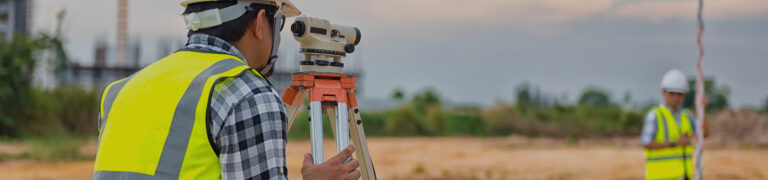
If you’ve ever seen a person standing on the side of the road, wearing a bright safety vest, looking through an instrument on a tripod, that may not have been a camera or a telescope they were using.
The total station has been around since 1971 and is used to measure distance and vertical and horizontal angles. It’s commonly used in civil engineering, construction, and surveying and can assist in making maps, identifying property lines, and determining precisely where a new road or building should be located.
According to the U.S. Department of Defense (DOD), GPS is “a satellite-based navigation system that helps people find their precise location on Earth.” GPS technology as we know it today began as a DOD project in 1973. It was initially reserved for military use, but in 2000 it became available to anyone with the necessary equipment after President Clinton issued an executive order.
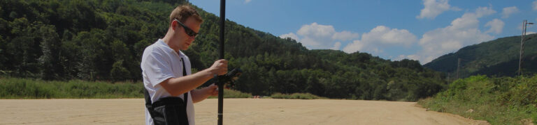
21st Century Total Station
The contemporary total station integrates technological advances such as robotics, GPS, and remote-control capabilities. Data from these total stations can be downloaded and used with software to render vivid 3D images.
Unmanned, remote-controlled aircraft, sometimes called Unmanned Aerial Vehicles (UAV), have been used for military purposes and surveying/mapmaking for many years. 2006 marked the first use of drones for other commercial and personal purposes, such as delivery and photography.
As with many industries, artificial intelligence (AI) revolutionized the GIS and geospatial sectors. Identifying topographic features in satellite images is just one of many current AI applications, and its future potential in the geospatial field is tremendous.
Advance Your Career with a Graduate Certificate in GIS
The University of Texas Permian Basin has served the GIS and geospatial industries for more than 20 years. Our close association has given UT Permian Basin an up-to-date, insider’s perspective of the industry that we’ve drawn upon in creating the curriculum for our online GIS and Geospatial Certificate.
This 12-credit graduate certificate program helps you develop practical skills that can benefit individuals in the oil and gas industry, the geospatial industry, and environmentally oriented careers. In just four courses, you’ll explore the technology, practices, and principles at work in the geospatial industry today.
The Convenient Way to Earn Career-Enhancing Credentials
Delivered through asynchronous, 100% online courses, our graduate program provides you with exceptional convenience and flexibility. You can complete coursework on your own schedule, practically anywhere, enabling you to learn around any job or family responsibilities you might have. Each course lasts eight weeks and is taught by the same acclaimed educators who teach the courses at the UT Permian Basin campus.
Explore today’s GIS and geospatial technology and trends as you gain a career-enhancing credential in our online GIS and Geospatial Certificate program!
Sources:
https://www.thoughtco.com/the-history-of-cartography-1435696
https://www.gislounge.com/mapping-through-the-ages
https://www.aaas.org/programs/scientific-responsibility-human-rights-law/overview-geospatial-project
https://eos.com/blog/geospatial-technology
https://geospatialtech.com/
https://www.esri.com/about/newsroom/arcnews/geospatial-technology-and-the-future-of-the-city
https://ndrive.com/brief-history-gps-car-navigation/#:~:text=In%201990%2C%20Mazda%20introduced%20the,built%20into%20the%20actual%20car
Other articles you may be interested in:
-
On December 26, 2004, a massive earthquake struck beneath the Indian Ocean and sent a wall of water nearly 100 feet high outward. It barreled into South Asia at 30 miles an hour, wiping out communities before most people even knew what was coming. By the time the waves crossed the ocean, nearly 230,000 lives had…
-
Imagine you’re commuting to work and your Google Maps loses signal. Suddenly, the little blue dot stops moving and you don’t know where you are. Panic ensues (for some of us). Modern devices constantly broadcast our location through GPS, Wi-Fi, cell towers, and apps. We’re basically walking beacons of sensitive data. But here’s the flip side:…
-
Flu season is here again, with all its aches, pains, and fevers. But scientists have a powerful tool to fight back. The GPS technology used to plot your rush-hour route home? It also powers GIS (Geosciences Information System) tools that help public health officials pinpoint infectious disease outbreaks, limit their spread, and spot gaps in…